 Follow
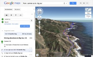
Google has added a 3D aerial route preview option to its Google Maps product.
With the new feature, Google Maps users can fly alongside routes to get a birds-eye view of directions while planning road trips, biking excursions, hiking trips or regular city commutes.
The 3D preview feature — colloquially referred to as “helicopter view” — is now a part of the Google directions experience. Users simply enter start, mid and endpoint destinations to get directions as usual, and a new 3D play button will appear next to the returned directions.